This is awesome! I'm playtesting a solo mapping RPG called I am the Forest and was wondering if there is a way to control the map/grid size. The game has a grid that is 4 hex vertical by 6 grid horizontal flats on top. Each hex is intended to have a "single feature" like a lake in one, part of a mountain range in one, a swamp in one, etc. Is that doable natively? I went through all the settings and couldn't find anything that would control those settings, but given that it is SVG, maybe there is something in the code I could manipulate?
You can choose the size of the map via the "Tags" dialog but there are only three predefined sizes: "small","medium" and "large". "Small" maps are significantly larger than what you need (smt.h around 10x10 hexes).
In the next update I'm planning to add the ability to request a map of specific dimensions. The goal is to make it possible to generate non-square maps and maps larger than current "large" one, but it could be useful for generating ver small maps as well :)
First of, this is awesome! I have two questions tho: 1 - is it possible to move the legend? I like eveything about it, except for that it sometimes places itself on top of features on the map. 2 - is it possible to make the font smaller or larger?
No biggie, a legend can be easily made in photoshop afterwards. Just a thought.
The legend can only be in one of the map corners and its location is chosen automatically to overlap map features as little as possible. As an alternative, you can Ctrl+click (or Cmd+click on mac) any map feature to add "stickers" to all the features listed in the legend and then hide the legend itself via the context menu (or by pressing L).
Yes. Open the Style dialog (via the context menu or by pressing S), click the "..." button and choose "Text".
Lately, when I generate a region and that region has two or more dangers in it, right-clicking on those dangers to open them in 1PDG results in identical maps – as if it only produces one random seed and sends that to 1PDG for all of them.
I wish that this generator was tied in somehow with the other generators you have made so that it could generate towns, dungeons, etc. all at the same time. it would make a great readymade campaign generator
It is tied with other generators: you can right-click a settlement or a dungeon to choose "Open in MFCG/VG/1PDG" to "zoom in". Anything tighter would require them to be merged into one huge generator, which would be to hard develope or even maintain.
Hi. No, custom feature names are not saved as a part of a permalink. But this generator is closer to getting a proper save/load feature than my other generators, so in the future it may become possible to save all the changes you make.
Would it be possible to get (an option for) a table on the page with the legend and metadata? Moving the legend off the image could help make it more readable, and it would be nice to see the tags and other information that is currently accessible only via the context menu.
Hi! Do I understand correctly that you are asking about moving the legend to the place where the list of hotkeys currently is? Sorry, I don't think it's technically possible, the generator can't access that static part of the page.
Ah, so if I understand correctly the generator has control over a single element of the page, and not multiple elements. I can see how that could make it more difficult.
Hmm... and it seems all we can see is the generator, not the generated content. That is, likely cannot embed the meta text in an alt tag or the like.
I do see that the meta text is in separate text elements in the SVG export, though. It would be fairly easy, after manually exporting the image as SVG, to tweak the appearance.
Thanks for the quick response. I've got some things to think about.
Hey Watabou, great job on this project! I was wondering if there is any way to automatically mass generate and download these maps as .png's (I wanted around a hundred)?
In all my "big" generators you can access the context menu on mobile, although methods differs from generator to generator. Here in Perilous Shores you just need to tap anywhere to open it. As far as I remember, in 1PDG long press is used for the same purpose. Both methods are less discoverable than a menu button, but both allow the menu to be a context menu with different items depending on where it is activated.
Is there an option to remove a certain feature from map? Let's say I don't want a certain settlement, can I delete or hide it? I know you can hide all of them, but is it possible with just one?
Currently it is not possible to remove individual map features. You can hide all the settlements (Details > Towns > Hidden). Or you can remove a specific settlement from the almanac ([Town name] > Remove from almanac), but this only removes its name from the legend.
It is very easy to remove a town icon from an exported SVG. For example, you can open it in Chrome, right-click the icon and choose "Inspect". Then right-click the enclosing group of the highlighted element (that will be the group for the whole icon) and choose "Delete element".
The legend is moveable in the city generator, but here its position is always chosen automatically to block as few map features as possible (preferring the top left corner). If the legend blocks something you need, you can make it smaller by selecting a smaller font.
I love this generator, so good. I would love to be able to switch Settlements to dangerous places and vice versa, as I never can get enough skulls to show even on evil or perilous tags. Your continual improvements are great!
First of all, thank you for making such an awesome tool.
I had a couple questions regarding how to use it and if there's any way it could be modified for different uses.
1. Is there a way to edit the name for the entire region? I know you can edit location names or add them to the almanac/legend, but I haven't been able to figure out how to change the region name.
2. Are there plans in the future to be able to add locations? That way theoretically every hex could be labelled for reference - possibly as an alternative to the hex number request in one of the other comments.
3. Is there any possibility that in the future one will be able to edit the procedurally-generated map? Adding a forest hex, mountain, or settlement, moving a coastline, etc. Being able to hide hexes, locations, or roads would be helpful as well, so that the map could be shown to the players without revealing secrets.
4. Is there any way to add or modify assets (e.g. more tree types, adding castles/temples/cave icons)?
Yes. Right-click the region name and choose "Edit name" in the context menu.
Maybe in the future I'll add the ability to mark hexes with "pins" like in MFCG, but not anytime soon. In any case labelling every hex this way would look ugly. Numbered hexes will be implemented soon.
To make maps editable in this generator is not very hard, but it would require much time and this is not the sort of coding I like. You can hide towns, dungeons and roads via the Details submenu of the context menu.
There is no way to add or edit assets because there are no assets here. Every icon is procedurally generated: for example if I wanted to add palm trees to the generator I would have to write a method for drawing them, not to draw them manually and save it as an image.
After making a custom style, I
exported to PNG and the colors were orangified. Instead exporting to SVG
kept the colors. Using Inkscape to re-export the SVG, I got a PNG with the
un-oranginated style.
Here's the style: colorful.json. Below are the original colors (first) and the oranginal ones (second).
Exported from Perilous Shores as SVG, then loaded to Inkscape and re-exported as PNG Exported from Perilous Shores as PNG
That's weird. For me PNG export works normally both in general and with your custom style. Also I didn't receive such complains before. Have you tried PNG export in my other generators? They almost identical code for export and they should exhibit the same behaviour.
Ah, turns out it is caused by a Firefox plugin: Canvas Defender. Disabling that plugin gets me normal colors. The plugin alters the HTML canvas behavior by adding some randomness. The plugin messed with all five of the exporters I tried: Shores, Neighborhood, Village, Dungeon, and Rose.
Incredible map generator indeed. I've used some of your generators (one page dungeon, Compass Rose, Sigil and this one) in my last game jam project "Projet-Z" and even in its itcho's presentation page. So, thanks for these wonderful tools that helped me a lot !
Thanks. Via the context menu you can rename items in the legend, delete existing items and add new ones. But it is not really possible to create new features: for example if you right-click an empty place on the map there won't be the "Add to almanac" item in the menu.
Thank you. There is no "built-in" way for such integration, but I guess you can just manually roll encounters (using other generators or tables) for specific hexes depending on their type?
Got it. Thanks. What I'm looking for is populating an entire map. I have a sandbox content generation engine I'm working on - so something programmatic would work best (say a JSON or YAML file).
Is there any chance a future version will allow us to copy a link to a specific region to save and restore later? I absolutely love how useful this generator is especially now that dungeons and cities/villages are connected, and am hoping I can save a specific seed for use in an on-going tabletop campaign.
I am planning to implement permalinks for all my "big generators" and Perilous Shores is next in the queue to get this feature (and the only one because the rest of "big generators" already have it).
Just learned you can also zoom out MFCG maps to Azgaar's Fantasy Map Generator. Amazing! Now if only these region maps correlated better with Azgaar's overworld, though I suppose you could edit it.
Though how amazing would it be if you could go back-and-forth between PS and an Azgaar map cell, zoom in to / out from MFCGs, VGs, & 1PDGs, and all of it linked up nicely?
Oh man and then if there's ever integration with Eigengrau's Generator... mind blown You'd have the ultimate TTRPG map generator.
It is a great feature but needs one thing. I had a PS map and clicked through to a village. In PS the beach and village were on the east coast, when the village was generated the village had water on its North West shore. We really need a check box to say where the water needs to be.
It's implemented in MFCG and probably will be implemented in VG as well, but honestly I'm not sure it's worth the trouble. After all you can just to turn a map in VG as you need it (shift+drag anywhere).
This is great! Any chance you could add numbers as an option for hexes? like in the center of hex. This could make it suitable for pbem type of ttrpg or if playing with friends in discord and being able to call out a hex number for where they want to move to etc.
Could you give me an example of a decently looking hex map with hexes numbered? It wouldn't be much work just to add numbers but I have no idea how to do it without making everything (i.e. both the map and the numbers) unreadable…
This example i made with another 3rd party Hex grid app and also paint.net, i wasn't about to set it to single or just double digits. In your map generator, you could make an option to have the number show top or center or bottom of a hex.
Maybe also have font color for Hex number and size as options too, bigger font number might make it more readable.
And the user could turn off (if its possible) the little 1-6 table denoting POI locations to make it easier to read hex numbers. As they could easily export a version of the map with out hex/numbers and have the 1-6 legend table denoting the POI so the map is not obscured in anyway. The hex version could be for movement only.
Thanks! So the idea is to use colour to separate numbers from the rest of the map, right? It probably won't help with multicoloured maps, but then a user just needs to switch to a different style. I'll try implementing it.
Well, yeah, R creates a new region AND switches the tilt mode (the same is true for switching the tilt mode via the context menu). When switching from flat topped hexes to pointy topped ones resulting regions bear some resemblance to each other. I can try making it work for tilted hexes as well, but details will be different anyway (rivers, settlements etc).
Wow! Just Wow! I came back to this after 4 months and I am blown away with the progress of this web app. You have implemented everything that one needs to generate interesting lands for OSR RPG maps. Amazing.
Thnx for the answer and for the reference to the explanation, it's very helpful!
Sorry for bothering you, but, I am an engineer and I more or less understand the way the generators might be implemented, what like the most in your generators is the visual style of the final results: it's minimalistic, but still very polished and more or less ready to be used in games (at least in some genres).
Can I ask if it's you who create visual style of the generators or do you work with artists who help you with it? Are there any good references you gather your visual-inspiration from?
Since most of my generators are map generators, my main source of inspiration is Cartographers' Guild.
If you haven't encountered it yet, I highly recommend Here Dragons Abound blog. Its author is even more concerned with visual style than me and he describes there how he achieved his results in procedural generation of maps.
HO LEE JIBBUS! Just came back to this thing after a couple of months and my GOD it was almost perfect when I last saw it, but when I used it again it was WAAAAAY better than I could've imagined.
Always amazing ! It kicks in my exploration itch and I wondered if you would consider a "tile mode" where you may navigate (with up, down, left, right arrows) a larger world one map at a time. Maybe it would be easier if borders could match between side by side tiles. Could not be so easy tough.
Couldn't understand how to change text fonts, is there a list of supported fonts somewhere ?
Thanks! You can use any font installed on your computer. I know it's not convenient to type font names manually. Unfortunately, I couldn't find a way to get a list of them to show as it a combobox or something.
you're truly amazing! do you take actual real-life geographical logic into account when designing the parameters? I know I should probably check the logs before asking but I just had to say how amazing this is!
← Return to generator
Comments
Log in with itch.io to leave a comment.
This is awesome! I'm playtesting a solo mapping RPG called I am the Forest and was wondering if there is a way to control the map/grid size. The game has a grid that is 4 hex vertical by 6 grid horizontal flats on top. Each hex is intended to have a "single feature" like a lake in one, part of a mountain range in one, a swamp in one, etc. Is that doable natively? I went through all the settings and couldn't find anything that would control those settings, but given that it is SVG, maybe there is something in the code I could manipulate?
You can choose the size of the map via the "Tags" dialog but there are only three predefined sizes: "small", "medium" and "large". "Small" maps are significantly larger than what you need (smt.h around 10x10 hexes).
In the next update I'm planning to add the ability to request a map of specific dimensions. The goal is to make it possible to generate non-square maps and maps larger than current "large" one, but it could be useful for generating ver small maps as well :)
First of, this is awesome! I have two questions tho:
1 - is it possible to move the legend? I like eveything about it, except for that it sometimes places itself on top of features on the map.
2 - is it possible to make the font smaller or larger?
No biggie, a legend can be easily made in photoshop afterwards. Just a thought.
Ah, I see. That is awesome! Thank you. And again, thank you for the awesome generators!
Lately, when I generate a region and that region has two or more dangers in it, right-clicking on those dangers to open them in 1PDG results in identical maps – as if it only produces one random seed and sends that to 1PDG for all of them.
I'll check this, thanks! It sounds more like a glitch with the context menu, than with the generation itself.
How can you export to print your map?
Right-click to open the context menu, then Export as > PNG or SVG.
I wish that this generator was tied in somehow with the other generators you have made so that it could generate towns, dungeons, etc. all at the same time. it would make a great readymade campaign generator
It is tied with other generators: you can right-click a settlement or a dungeon to choose "Open in MFCG/VG/1PDG" to "zoom in". Anything tighter would require them to be merged into one huge generator, which would be to hard develope or even maintain.
awesome! I will try that when I get back to my computer
Hello, is there any work around with the Permalink? My changes doesn't save and it will generate the original names with the map
Hi. No, custom feature names are not saved as a part of a permalink. But this generator is closer to getting a proper save/load feature than my other generators, so in the future it may become possible to save all the changes you make.
https://pin.it/6NiyTze Thanks for the strength, hope to do the same.
hi watabou, I wanted to know if there is a way to optimize the mobile version a little better, it ends up being bad to use the generator via mobile
What would you like to be optimized on mobiles? Performance, UI?
hi Watabou, I really like what you've done here.
Would it be possible to get (an option for) a table on the page with the legend and metadata? Moving the legend off the image could help make it more readable, and it would be nice to see the tags and other information that is currently accessible only via the context menu.
Hi! Do I understand correctly that you are asking about moving the legend to the place where the list of hotkeys currently is? Sorry, I don't think it's technically possible, the generator can't access that static part of the page.
Ah, so if I understand correctly the generator has control over a single element of the page, and not multiple elements. I can see how that could make it more difficult.
Hmm... and it seems all we can see is the generator, not the generated content. That is, likely cannot embed the meta text in an alt tag or the like.
I do see that the meta text is in separate text elements in the SVG export, though. It would be fairly easy, after manually exporting the image as SVG, to tweak the appearance.
Thanks for the quick response. I've got some things to think about.
As an alternative, an option to output the legend to a .txt file and being able to show just the numbers on the map would be fantastic. :-)
I'll think about it👍
Meanwhile you can easily hide the legend in svg right in Chrome:
Hey Watabou, great job on this project! I was wondering if there is any way to automatically mass generate and download these maps as .png's (I wanted around a hundred)?
Thank you!
Unfortunately, there is no way to do it, sorry.
Is there any way to change the text colour to optimise the contrast?
Currently all the text is drawn using the "Outlines" colour and outlined with the "Paper" colour. Both colours can be edited in the "Style" dialog.
Hey watabou. Great job on all of your generators. Just a feedback about usability.
I noticed that only one of them has a menu button. All others required a right click to access the context menu.
A visible menu button allows us to use your generators on mobile.
I don't know if you intentionally left mobile out of it but thought it could be of some help to let you know.
Congrats again.
Thanks!
In all my "big" generators you can access the context menu on mobile, although methods differs from generator to generator. Here in Perilous Shores you just need to tap anywhere to open it. As far as I remember, in 1PDG long press is used for the same purpose. Both methods are less discoverable than a menu button, but both allow the menu to be a context menu with different items depending on where it is activated.
Oh that's great. Maybe just some kind a message about it and we should be good to go. Thanks for your reply and clarification.
Is there an option to remove a certain feature from map? Let's say I don't want a certain settlement, can I delete or hide it? I know you can hide all of them, but is it possible with just one?
Currently it is not possible to remove individual map features. You can hide all the settlements (Details > Towns > Hidden). Or you can remove a specific settlement from the almanac ([Town name] > Remove from almanac), but this only removes its name from the legend.
It is very easy to remove a town icon from an exported SVG. For example, you can open it in Chrome, right-click the icon and choose "Inspect". Then right-click the enclosing group of the highlighted element (that will be the group for the whole icon) and choose "Delete element".
Super useful tip about svg, thanks so much!
Can you make the legend be moveable? I thought you could move the legend, but I don't see where you can do that.
The legend is moveable in the city generator, but here its position is always chosen automatically to block as few map features as possible (preferring the top left corner). If the legend blocks something you need, you can make it smaller by selecting a smaller font.
Fantastic! thank yoU!
I love this generator, so good. I would love to be able to switch Settlements to dangerous places and vice versa, as I never can get enough skulls to show even on evil or perilous tags. Your continual improvements are great!
First of all, thank you for making such an awesome tool.
I had a couple questions regarding how to use it and if there's any way it could be modified for different uses.
1. Is there a way to edit the name for the entire region? I know you can edit location names or add them to the almanac/legend, but I haven't been able to figure out how to change the region name.
2. Are there plans in the future to be able to add locations? That way theoretically every hex could be labelled for reference - possibly as an alternative to the hex number request in one of the other comments.
3. Is there any possibility that in the future one will be able to edit the procedurally-generated map? Adding a forest hex, mountain, or settlement, moving a coastline, etc. Being able to hide hexes, locations, or roads would be helpful as well, so that the map could be shown to the players without revealing secrets.
4. Is there any way to add or modify assets (e.g. more tree types, adding castles/temples/cave icons)?
Another fun generator :)
After making a custom style, I exported to PNG and the colors were orangified. Instead exporting to SVG kept the colors. Using Inkscape to re-export the SVG, I got a PNG with the un-oranginated style.
Here's the style: colorful.json. Below are the original colors (first) and the oranginal ones (second).
That's weird. For me PNG export works normally both in general and with your custom style. Also I didn't receive such complains before. Have you tried PNG export in my other generators? They almost identical code for export and they should exhibit the same behaviour.
Ah, turns out it is caused by a Firefox plugin: Canvas Defender. Disabling that plugin gets me normal colors. The plugin alters the HTML canvas behavior by adding some randomness. The plugin messed with all five of the exporters I tried: Shores, Neighborhood, Village, Dungeon, and Rose.
is there a way to change the names of the cities/sites? I'm new to this website so I don't know.
Right-click the site at the map or its name at the legend to open the context menu > Edit name
Thank you so much! I love your generators.
Cannot upload previously saved color selections. Chrome/Brave browser.
Could you send me that saved style file?
Sure. Where do you want me to send it? I don't see a file attachment on this site.
watabou at gmail
This is so cool, and I'm having a lot of fun generating maps and new ideas with it.
Incredible map generator indeed. I've used some of your generators (one page dungeon, Compass Rose, Sigil and this one) in my last game jam project "Projet-Z" and even in its itcho's presentation page. So, thanks for these wonderful tools that helped me a lot !
I'm glad it was useful! Cheers!
Amazing Generator. Is it possible to edit the Legend and the location symbols?
Thanks. Via the context menu you can rename items in the legend, delete existing items and add new ones. But it is not really possible to create new features: for example if you right-click an empty place on the map there won't be the "Add to almanac" item in the menu.
This is beautiful. Can I integrate this with some hex content generation?
Thank you. There is no "built-in" way for such integration, but I guess you can just manually roll encounters (using other generators or tables) for specific hexes depending on their type?
Got it. Thanks. What I'm looking for is populating an entire map. I have a sandbox content generation engine I'm working on - so something programmatic would work best (say a JSON or YAML file).
Is there any chance a future version will allow us to copy a link to a specific region to save and restore later? I absolutely love how useful this generator is especially now that dungeons and cities/villages are connected, and am hoping I can save a specific seed for use in an on-going tabletop campaign.
I am planning to implement permalinks for all my "big generators" and Perilous Shores is next in the queue to get this feature (and the only one because the rest of "big generators" already have it).
Very cool. I would love to have a persistent seed to be able to access for a campaign as well. Thanks for the lovely generator.
Just Fantastic!
Is there any chance of a roads option connecting towns/villages in the future?
Thanks!
Roads are on my list, I'll probably try implementing them properly in the next update (https://twitter.com/watawatabou/status/1409655466846609410).
Procedural generation at its finest.
This is insanely good! Thanks 🙂
Any chance you could add the preset from the last image here? It's quite unique.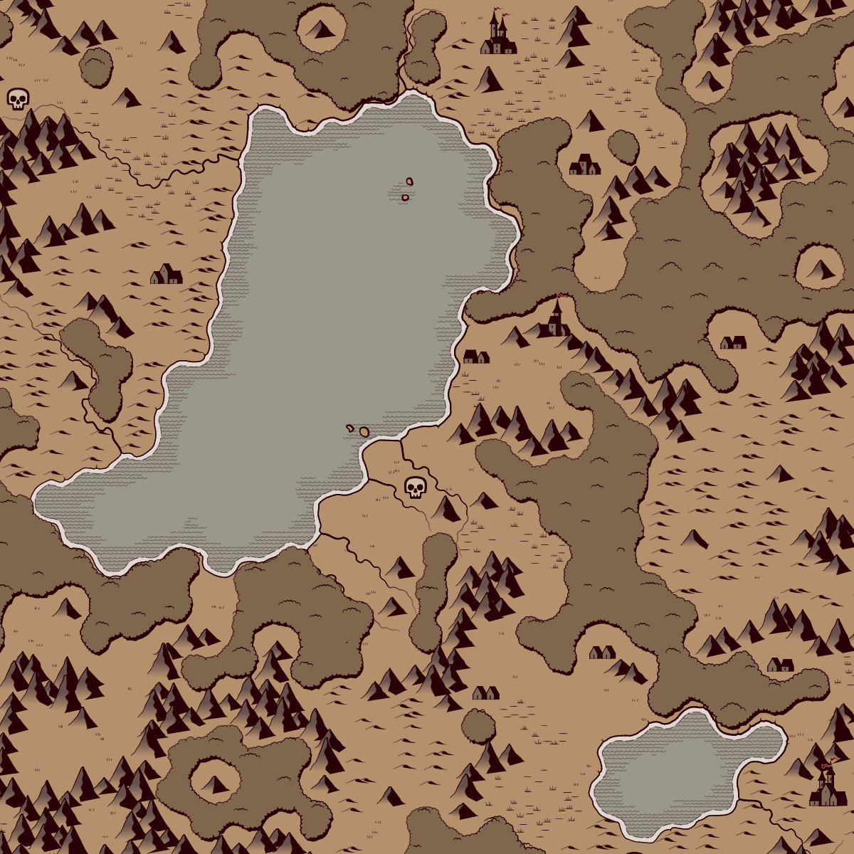
Here it is: https://watabou.github.io/perilous-shores/palettes/bold.json. Save it on your computer and Load in the Style dialog.
Thank you!!
This is incredible
Just learned you can also zoom out MFCG maps to Azgaar's Fantasy Map Generator. Amazing! Now if only these region maps correlated better with Azgaar's overworld, though I suppose you could edit it.
Though how amazing would it be if you could go back-and-forth between PS and an Azgaar map cell, zoom in to / out from MFCGs, VGs, & 1PDGs, and all of it linked up nicely?
Oh man and then if there's ever integration with Eigengrau's Generator...
mind blown
You'd have the ultimate TTRPG map generator.
It is a great feature but needs one thing. I had a PS map and clicked through to a village. In PS the beach and village were on the east coast, when the village was generated the village had water on its North West shore. We really need a check box to say where the water needs to be.
It's implemented in MFCG and probably will be implemented in VG as well, but honestly I'm not sure it's worth the trouble. After all you can just to turn a map in VG as you need it (shift+drag anywhere).
I can turn off the labels, then flip it, and label it myself.
This is great! Any chance you could add numbers as an option for hexes? like in the center of hex. This could make it suitable for pbem type of ttrpg or if playing with friends in discord and being able to call out a hex number for where they want to move to etc.
Could you give me an example of a decently looking hex map with hexes numbered? It wouldn't be much work just to add numbers but I have no idea how to do it without making everything (i.e. both the map and the numbers) unreadable…
This example i made with another 3rd party Hex grid app and also paint.net, i wasn't about to set it to single or just double digits. In your map generator, you could make an option to have the number show top or center or bottom of a hex.
Maybe also have font color for Hex number and size as options too, bigger font number might make it more readable.
And the user could turn off (if its possible) the little 1-6 table denoting POI locations to make it easier to read hex numbers. As they could easily export a version of the map with out hex/numbers and have the 1-6 legend table denoting the POI so the map is not obscured in anyway. The hex version could be for movement only.
I hope the example helps.
Thanks! So the idea is to use colour to separate numbers from the rest of the map, right? It probably won't help with multicoloured maps, but then a user just needs to switch to a different style. I'll try implementing it.
How did it go?
Just a heads up: looks like the R key is creating a new region instead of switching the tilt mode.
Well, yeah, R creates a new region AND switches the tilt mode (the same is true for switching the tilt mode via the context menu). When switching from flat topped hexes to pointy topped ones resulting regions bear some resemblance to each other. I can try making it work for tilted hexes as well, but details will be different anyway (rivers, settlements etc).
Wow! Just Wow! I came back to this after 4 months and I am blown away with the progress of this web app. You have implemented everything that one needs to generate interesting lands for OSR RPG maps. Amazing.
Keep up the fantastic work.
Thank you!
Hi,
I wonder if it's possible to get the source code of the generator to use it in video games development?
Sorry, I don't usually open projects which I'm still working on. But if you are interested, there is a post where I explain how this generator works: https://www.patreon.com/posts/generation-in-41103311.
Thnx for the answer and for the reference to the explanation, it's very helpful!
Sorry for bothering you, but, I am an engineer and I more or less understand the way the generators might be implemented, what like the most in your generators is the visual style of the final results: it's minimalistic, but still very polished and more or less ready to be used in games (at least in some genres).
Can I ask if it's you who create visual style of the generators or do you work with artists who help you with it? Are there any good references you gather your visual-inspiration from?
Since most of my generators are map generators, my main source of inspiration is Cartographers' Guild.
If you haven't encountered it yet, I highly recommend Here Dragons Abound blog. Its author is even more concerned with visual style than me and he describes there how he achieved his results in procedural generation of maps.
HO LEE JIBBUS! Just came back to this thing after a couple of months and my GOD it was almost perfect when I last saw it, but when I used it again it was WAAAAAY better than I could've imagined.
Always amazing ! It kicks in my exploration itch and I wondered if you would consider a "tile mode" where you may navigate (with up, down, left, right arrows) a larger world one map at a time. Maybe it would be easier if borders could match between side by side tiles. Could not be so easy tough.
Couldn't understand how to change text fonts, is there a list of supported fonts somewhere ?
Thanks! You can use any font installed on your computer. I know it's not convenient to type font names manually. Unfortunately, I couldn't find a way to get a list of them to show as it a combobox or something.
you're truly amazing! do you take actual real-life geographical logic into account when designing the parameters? I know I should probably check the logs before asking but I just had to say how amazing this is!
Thank you! But what do you mean designing the parameters? There is a post where generation of these maps is described.
What does "switch tilt mode" (R) do?
Switches to one of the modes listed in the Hexes submenu of the context menu. It's effect is more visible if the grid is on.