I can't get this to work properly on Firefox, but it works apparently just fine on chrome. what is going on?? Chrome it works just fine, but it's slow and laggy.
Awesome tool! is there a way for me to generate just the json from an api call or something in my playcanvas game? I would love to have totally ranom maps for my quest game. Happy to pay if i get traffic!
Cool thats fine, i see when i download json data "extendable" pin points at the end of rivers and roads, is that incorporated? Would love to extend a map or stitch 2 together, is that possible or no? Maybe extendable is for a future feature?
Grove is not a forest, it's a relatively small group of trees. This tag makes the generator to spawn trees only in the centre of a map, resulting in an oasis-like "village in a grove". Select "Layers > Trees > Many" to make the grove denser.
No, sorry, none of my generators have a save/load feature at the moment. But why would you need it in the Village Generator? There is nothing you can edit here, so why isn't a permalink enough?
A permalink is definitely enough to be used. I had just not kept record of the link and was wondering of another way of importing previous maps. Than you for the information and reply! Still an amazing generator!
Seconding this! I'm currently running a DND game where I have a cliffside village; I cheated and made a coastal village, and just changed the water to stone in an editing program, but something that would let us handle that natively would be great ^_^
I just don't think mountain villages are different enough to support them as a special case. I'm planning on adding "cliffs" as an optional feature, maybe they can be used to make a map look more mountainous.
Very handy program but for some reason the "roads=####" parameter in the generated url doesn't seem to register. Whenever I try to open a bookmark to a village where I've re-rolled the village it always returns to the default road layout and the "roads=####" part vanishes from the url.
Would it be possible to add an option for generating a railroad as part of the map? I know this generator is mostly intended for medieval fantasy, but with a railroad feature it could easily cover steampunk and Western settings as well.
Sometimes I'll get a generation that's near-perfect, but it has a road or a river that's just not quite where I'd like it to be in comparison to a world map I'm trying to match it to. Would it be possible to add an option to place guide markers so users can give a general idea where they want these roads and rivers to meet the edges of the map? Ofc I could also just sit here for 3 hours clicking "generate" until I find one that actually is perfect.
And/or something similar to the Warp feature in the City generator so you can manipulate stuff around.
I'll think about it, but yeah, actually the idea was that you could generate villages until you got the right one. Generation takes a fraction of a second, and it's not like there are a huge number of parameters, so it shouldn't take 3 hours.
If you have specific requirements for a river or a highway, you can first find a map that satisfies those requirements ignoring the village itself. Then you can "Reroll village" (via the context menu or by pressing Shift+Enter) to get a good distribution of secondary roads and houses.
I hear you, and maybe I just got bad luck (or maybe I'm just too particularly picky) but it took me hours to find one where the river and roads went the right direction with the right orientation specific to what I needed (I also had to do this for 5 different towns, so it really was an all-day event). "Reroll village" was the quickest part after I found the exact right setup.
hello, would it at all be possible to add an option to hide the roads in the village. I see the option to remove driveways, but completely hiding roads would be nice for making something like a raider or bandit camp in the woods.
I'll probably do it, but for now you can try making them almost invisible via the Style dialog: Wide: 0, Narrow: 0, Outlining: None, Color: the same as the ground colour.
Still using the VG with my greatest satisfaction. Congrat !
I am using some JSON exports of VG. I analyze them and create splatmap in UNITY. I am able to create different textures for different features (water, fields, square, ...). I have troubles with the "water" MultiPolygon geometry, in case of tag "island".
Here the PNG :
And a splatmap of the polygons of "water", except the last polygon :
It seems that, contrary to other generations ("pond", "river", ...), in case of "island", the last polygon being equal to "earth", the logic is "earth", minus previous polygons ? Is it correct ?
I have an other question. In a generation with tag "estuary", I got that :
And the splatmap of all polygons of "water" is :
Seems good. But I also draw vertices of each polygon (not obvious to see, but they are the small yellow points). I got "extra" points. Are they still polygons of something ?
Yes, for islands the "main" water polygon is the last one and the rest of them are "holes" in it.
I have no idea what those rogue vertices are in your image. Usually, there is only one water polygon in an estuary map unless there is an additional island. Could it be a degenerate zero area island or something like that?
This is such a great creation, thanks for all your work on this it is much appreciated. I have used it in my adventures and would certainly send you a copy if you would like to see it. I made sure to link to your page here.
First of all, amazing work! Thank you Watabou for creating such a beautiful and inspiring tool.
I noticed that most of the houses in the generator are positioned perpendicular to the road. In reality, some houses are often parallel to the road as well. Have you considered adding an option to let users customize the orientation of the houses? I think it could add even more flexibility and realism to the tool.
I agree that it would nice to have such a feature here, but for now I don't know how this could be implemented (these two generators are completely different). Hopefully I'll come up with something eventually.
A village was created using these tags. And exported it as a json file. The problem is that the road in the red area in the picture below is not exported.
It's "farmland," not "uncultivated." And I don't have the link. It seems to me that roads created with the "isolated" tag have the same problem. And the road expressed as a dot is exported.
There is no such problem in general. I mean, if a road is not exported then it's something more specific, than just the "isolated" tag which I tested many times before (especially since it's a default tag now). Here is a very similar village:
As you can see, both the regular (solid) part of the road and the trail part (dotted) are present. Anyway, if you will be able to reproduce the bug, please send me the link so can examine the case more closely.
It would be fantastic for medieval fantasy games if we could add in an option for a manor house, chapel/church, and graveyard. This is a great tool! Thank you for making it!
What a fantastic tool! I love it! Does anyone however know if there is there a way to add labels to the map in the editor right now? For example mark a baker, name a river or forest, etc?
Hi! I love your work and on procgen arcana! I just wanted to ask if there is someway to use your generators offline? I ask as my country suffers a lot of either power cuts, rolling blackouts, internet outages, etc. So if I were able to run this locally on my craptop, it could still enjoy your work? The github repo's seems very out of date, especially the town generator. Whether its a yes or a no, thank you for your time in advance!
Occasionally I build desktop versions of my generators (both for macOS and Windows) for my patrons. If I understand correctly you can run the generators offline using the Itch app, but I haven't tried this myself.
Currently there is no way to combine different types of water features - this is harder than it might seem. However, you can select "estuary" to get a river and a coast on the same map.
This generator used to be amazing, but now it's just mind-blowing. I've seen your future plans post on Patreon, but do you have any plans to include roundhouses (or are they there and I've missed it)? Thatched roundhouses were quite prevalent in the Dark Ages. With the new Palisades feature and Roundhouses you would have classic Arthurian period gamers jumping up and down with excitement. Thanks for the generator - well done!
There are no roundhouses in the generator and I've never considered them as I aim for the style(s) associated with later ages. In theory, I could implement roundhouses as another "roof type", but I don't think that lining the same roads with circular shapes would look like anything historically accurate :)
This might be a big ask or just a suggestion. Your new spotlight feature, made me realize the potential for it. I usually export the maps from your generators and use them in GIMP or Inkscape. I put a black layer over them and then another layer with a small gradient that cuts into the black overlay creating a visible area for the party. Not sure how well that would work built into the generator, but I figured I'd offer the suggestion.
As always, I need to express how much I love your work. Thank you for all that you do!!!
I get the idea, but to be honest, I doubt I my implementation of this functionality would be any more convenient than using any generic graphics editor with different types of brushes and stuff and, more importantly, the ability to save, restore and update the mask layer.
I love the roads in the new update, looking even better than before!
Are there plans to include a tag to ensure a manor house / [timber] castle shows up on the map? I think having an option to fix a couple buildings -a keep, a church- would go a long way to helping them 'pop' as real communities.
Is there a way that I can upload a picture of my village and it will generate a picture like the one that is generated? I like the design of it and I want to try it for my school project requirements.
Watabou you are killing it! The amount of awesome improvements added in the last year have really elevated this generator to another level. I mean check this - I spent 30 seconds tweaking settings and this was the 1st map I rolled up: https://imgur.com/a/9Lhufrk
The details look so good! The new roads, the revised tree shadows you did a while back, and just all the little tweaks to fields, roofs, roads, etc. come together to make settlement maps that in my opinion rival certain professional subscription tools.
Hey! You created a really beautiful tool - my favourite of all of your works, I'm using it quite often. Just a question though - are you planning on adding numbers to buildings? It's just so I (and other people probably) could add description what you can find in which building, as "a house on the left" doesn't really work if you have 20 houses on a map :)
Putting a circle with a number in it over each building will mar the aesthetic, but allows for the option to create two images of the village - one unmarked to present to players and another with the numbers for reference/lookup.
← Return to generator
Comments
Log in with itch.io to leave a comment.
Interesting. I'll try to check this later (I only have Chrome and Safari installed at the moment).
What an amazing tool! Thank for all your hard work and efforts - adventure awaits!
Awesome tool! is there a way for me to generate just the json from an api call or something in my playcanvas game? I would love to have totally ranom maps for my quest game. Happy to pay if i get traffic!
Nope, sorry. This is not possible because this generator is a purely client-side application.
Cool thats fine, i see when i download json data "extendable" pin points at the end of rivers and roads, is that incorporated? Would love to extend a map or stitch 2 together, is that possible or no? Maybe extendable is for a future feature?
Kind of weird that "grove" option usually makes there be *less* trees, as big masses of trees are not generated
Grove is not a forest, it's a relatively small group of trees. This tag makes the generator to spawn trees only in the centre of a map, resulting in an oasis-like "village in a grove". Select "Layers > Trees > Many" to make the grove denser.
Thank you for all of these maps and keeping them free! They're fantastic
awesome! Will more parameters be added to this program? I want some village among hills and moutains,with some small castle.
Hello! Great generator, but I am wondering if it was possible to import a previous map into the generator outside of the link being saved? Thanks
No, sorry, none of my generators have a save/load feature at the moment. But why would you need it in the Village Generator? There is nothing you can edit here, so why isn't a permalink enough?
A permalink is definitely enough to be used. I had just not kept record of the link and was wondering of another way of importing previous maps. Than you for the information and reply! Still an amazing generator!
This is a great generator! I would like a zoom feature however other than that its perfect
Agreed. That would be great.
Love your generator!! Used it to make a map for our game <3
Could there be a mountain generation option for towns next to mountains or rivers that come from mountains? :D
Seconding this! I'm currently running a DND game where I have a cliffside village; I cheated and made a coastal village, and just changed the water to stone in an editing program, but something that would let us handle that natively would be great ^_^
I just don't think mountain villages are different enough to support them as a special case. I'm planning on adding "cliffs" as an optional feature, maybe they can be used to make a map look more mountainous.
Do you have an example of a mountain village map?
For sure! Here are a few that I had used for previous games:
https://www.artstation.com/artwork/zD8rzQ
https://www.reddit.com/r/dndmaps/comments/bowrus/mountain_village_inkarnate_my_f...
https://www.reddit.com/r/dndmaps/comments/jlcmn4/bramble_a_small_mountain_town/
https://www.pinterest.com/pin/city-river-mountain-cliff-farmland-forest--7754636...
https://www.peakpx.com/en/hd-wallpaper-desktop-nvoiu
Realised the second and third link links the first link for some reason :( I'm reposting them here!
https://www.reddit.com/r/dndmaps/comments/bowrus/mountain_village_inkarnate_my_f...
https://www.reddit.com/r/dndmaps/comments/jlcmn4/bramble_a_small_mountain_town/
Very handy program but for some reason the "roads=####" parameter in the generated url doesn't seem to register. Whenever I try to open a bookmark to a village where I've re-rolled the village it always returns to the default road layout and the "roads=####" part vanishes from the url.
Yeah, this will be fixed 👍
Hello. Would it be possible to change the background color to match different terrains, like deserts or mountainous regions?
You can change the background colour in the Style settings dialog (Style settings > Terrain > Ground).
Would it be possible to add an option for generating a railroad as part of the map? I know this generator is mostly intended for medieval fantasy, but with a railroad feature it could easily cover steampunk and Western settings as well.
Sometimes I'll get a generation that's near-perfect, but it has a road or a river that's just not quite where I'd like it to be in comparison to a world map I'm trying to match it to. Would it be possible to add an option to place guide markers so users can give a general idea where they want these roads and rivers to meet the edges of the map? Ofc I could also just sit here for 3 hours clicking "generate" until I find one that actually is perfect.
And/or something similar to the Warp feature in the City generator so you can manipulate stuff around.
I'll think about it, but yeah, actually the idea was that you could generate villages until you got the right one. Generation takes a fraction of a second, and it's not like there are a huge number of parameters, so it shouldn't take 3 hours.
If you have specific requirements for a river or a highway, you can first find a map that satisfies those requirements ignoring the village itself. Then you can "Reroll village" (via the context menu or by pressing Shift+Enter) to get a good distribution of secondary roads and houses.
I hear you, and maybe I just got bad luck (or maybe I'm just too particularly picky) but it took me hours to find one where the river and roads went the right direction with the right orientation specific to what I needed (I also had to do this for 5 different towns, so it really was an all-day event). "Reroll village" was the quickest part after I found the exact right setup.
hello, would it at all be possible to add an option to hide the roads in the village. I see the option to remove driveways, but completely hiding roads would be nice for making something like a raider or bandit camp in the woods.
I'll probably do it, but for now you can try making them almost invisible via the Style dialog: Wide: 0, Narrow: 0, Outlining: None, Color: the same as the ground colour.
Awesome, thank you!
Some little troubles with JSON file...
Hi Watabou,
Still using the VG with my greatest satisfaction. Congrat !
I am using some JSON exports of VG. I analyze them and create splatmap in UNITY. I am able to create different textures for different features (water, fields, square, ...). I have troubles with the "water" MultiPolygon geometry, in case of tag "island".
Here the PNG :
And a splatmap of the polygons of "water", except the last polygon :
It seems that, contrary to other generations ("pond", "river", ...), in case of "island", the last polygon being equal to "earth", the logic is "earth", minus previous polygons ? Is it correct ?
I have an other question. In a generation with tag "estuary", I got that :
And the splatmap of all polygons of "water" is :
Seems good. But I also draw vertices of each polygon (not obvious to see, but they are the small yellow points). I got "extra" points. Are they still polygons of something ?
Best Regards
Mallatius
Hi,
donde lo Puedo descargar para usarlo sin interne?
Here: https://www.patreon.com/posts/desktop-versions-96122791. Or install the itch.io app.
DM's across the world thank you for your work.
And if not, they should.
This is such a great creation, thanks for all your work on this it is much appreciated. I have used it in my adventures and would certainly send you a copy if you would like to see it. I made sure to link to your page here.
My pleasure! And yeah, I would love to see it :)
I'll send you a copy. Here is a link to my email. info@arcanumsyndicate.com
First of all, amazing work! Thank you Watabou for creating such a beautiful and inspiring tool.
I noticed that most of the houses in the generator are positioned perpendicular to the road. In reality, some houses are often parallel to the road as well. Have you considered adding an option to let users customize the orientation of the houses? I think it could add even more flexibility and realism to the tool.
Thanks again for your wonderful creation!
Hi! The results of a quick test look a little weird, but I'll think about:
Hi, love your work and really happy to see back to back updates for the village generator :)
I was wondering, do you planned to add the warps options from the city generator to the village one ? Or would it be too hard to do ?
Thanks!
I agree that it would nice to have such a feature here, but for now I don't know how this could be implemented (these two generators are completely different). Hopefully I'll come up with something eventually.
Hello,
Thank you for your great generator!
Would be cool to choose between various aspect ratios, when I print a map on a4 paper there is a lot of unused blank space
You can request a map with the aspect ratio you need by adjusting Size values in the "Map parameters" dialog ("Tags..." in the context menu).
For example: https://watabou.github.io/village-generator/?seed=1140703949&tags=island,no%20sq...
That is awesome, thanks.
You should be able to name the houses & roads.
tag : isolate, palisade, sparse, uncultivated
A village was created using these tags. And exported it as a json file. The problem is that the road in the red area in the picture below is not exported.
Do you have a link to this map so I can check how it exports for me?
Also these fields shouldn't be there if the 'uncultivated' tag is selected...
It's "farmland," not "uncultivated." And I don't have the link. It seems to me that roads created with the "isolated" tag have the same problem. And the road expressed as a dot is exported.
There is no such problem in general. I mean, if a road is not exported then it's something more specific, than just the "isolated" tag which I tested many times before (especially since it's a default tag now). Here is a very similar village:
https://watabou.github.io/village-generator/?seed=1026162478&tags=isolated,palis...
And that's how its exported version looks:
As you can see, both the regular (solid) part of the road and the trail part (dotted) are present. Anyway, if you will be able to reproduce the bug, please send me the link so can examine the case more closely.
I realized I made a mistake. Thank you very much for your helps.
It would be fantastic for medieval fantasy games if we could add in an option for a manor house, chapel/church, and graveyard. This is a great tool! Thank you for making it!
I don't know about graveyards, but I will probably add some larger, more complex and less generic buildings.
What a fantastic tool! I love it! Does anyone however know if there is there a way to add labels to the map in the editor right now? For example mark a baker, name a river or forest, etc?
Not at the moment, no. I plan to make it possible to label individual buildings when I implement random points of interest.
Is there a way to reload a town you've downloaded as a json
No, these json files can only be loaded in the City Viewer.
Do my town need to be small to add the walls
You can request a palisade for a village of any size by selecting the "palisade" tag.
i like it n find it useful
Hi! I love your work and on procgen arcana! I just wanted to ask if there is someway to use your generators offline? I ask as my country suffers a lot of either power cuts, rolling blackouts, internet outages, etc. So if I were able to run this locally on my craptop, it could still enjoy your work? The github repo's seems very out of date, especially the town generator. Whether its a yes or a no, thank you for your time in advance!
Occasionally I build desktop versions of my generators (both for macOS and Windows) for my patrons. If I understand correctly you can run the generators offline using the Itch app, but I haven't tried this myself.
Will let you know if the itch app works! :👍
Seems to work, will sub to patreon when I got the money for it c:
Amazing tool!
I'd like to select some of the options at the same time, like river + coast or pond.
Great job anyway!
Currently there is no way to combine different types of water features - this is harder than it might seem. However, you can select "estuary" to get a river and a coast on the same map.
This generator used to be amazing, but now it's just mind-blowing. I've seen your future plans post on Patreon, but do you have any plans to include roundhouses (or are they there and I've missed it)? Thatched roundhouses were quite prevalent in the Dark Ages.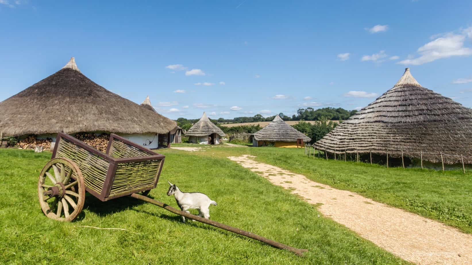
With the new Palisades feature and Roundhouses you would have classic Arthurian period gamers jumping up and down with excitement.
Thanks for the generator - well done!
There are no roundhouses in the generator and I've never considered them as I aim for the style(s) associated with later ages. In theory, I could implement roundhouses as another "roof type", but I don't think that lining the same roads with circular shapes would look like anything historically accurate :)
Yeah, you'd want to be able to turn off the roads too. No matter, still a great tool!
This might be a big ask or just a suggestion. Your new spotlight feature, made me realize the potential for it. I usually export the maps from your generators and use them in GIMP or Inkscape. I put a black layer over them and then another layer with a small gradient that cuts into the black overlay creating a visible area for the party. Not sure how well that would work built into the generator, but I figured I'd offer the suggestion.
As always, I need to express how much I love your work. Thank you for all that you do!!!
I get the idea, but to be honest, I doubt I my implementation of this functionality would be any more convenient than using any generic graphics editor with different types of brushes and stuff and, more importantly, the ability to save, restore and update the mask layer.
I love the roads in the new update, looking even better than before!
Are there plans to include a tag to ensure a manor house / [timber] castle shows up on the map? I think having an option to fix a couple buildings -a keep, a church- would go a long way to helping them 'pop' as real communities.
I don't know, maybe. But the current version occasionally spawns larger church-like buildings, sometimes more than one.
Is there a way that I can upload a picture of my village and it will generate a picture like the one that is generated? I like the design of it and I want to try it for my school project requirements.
Nope.
Watabou you are killing it! The amount of awesome improvements added in the last year have really elevated this generator to another level. I mean check this - I spent 30 seconds tweaking settings and this was the 1st map I rolled up: https://imgur.com/a/9Lhufrk
The details look so good! The new roads, the revised tree shadows you did a while back, and just all the little tweaks to fields, roofs, roads, etc. come together to make settlement maps that in my opinion rival certain professional subscription tools.
Awesome work as always!
Thank you!
Hey! You created a really beautiful tool - my favourite of all of your works, I'm using it quite often. Just a question though - are you planning on adding numbers to buildings? It's just so I (and other people probably) could add description what you can find in which building, as "a house on the left" doesn't really work if you have 20 houses on a map :)
Thanks for creating this generator.
How do you see this in practice? Would you like each building to have its number written on the top?
Putting a circle with a number in it over each building will mar the aesthetic, but allows for the option to create two images of the village - one unmarked to present to players and another with the numbers for reference/lookup.
Maybe an option to automatically add numbers to each house, and more fine-tuning one to just add option to context menu? What do you think?
I'll consider something like this👍
Amazing tool! :) I used it sometimes playing solo RPGs and playing alone D&D! I really love!
How can I get the source code of this generator?
You can not - this generator is not open source.