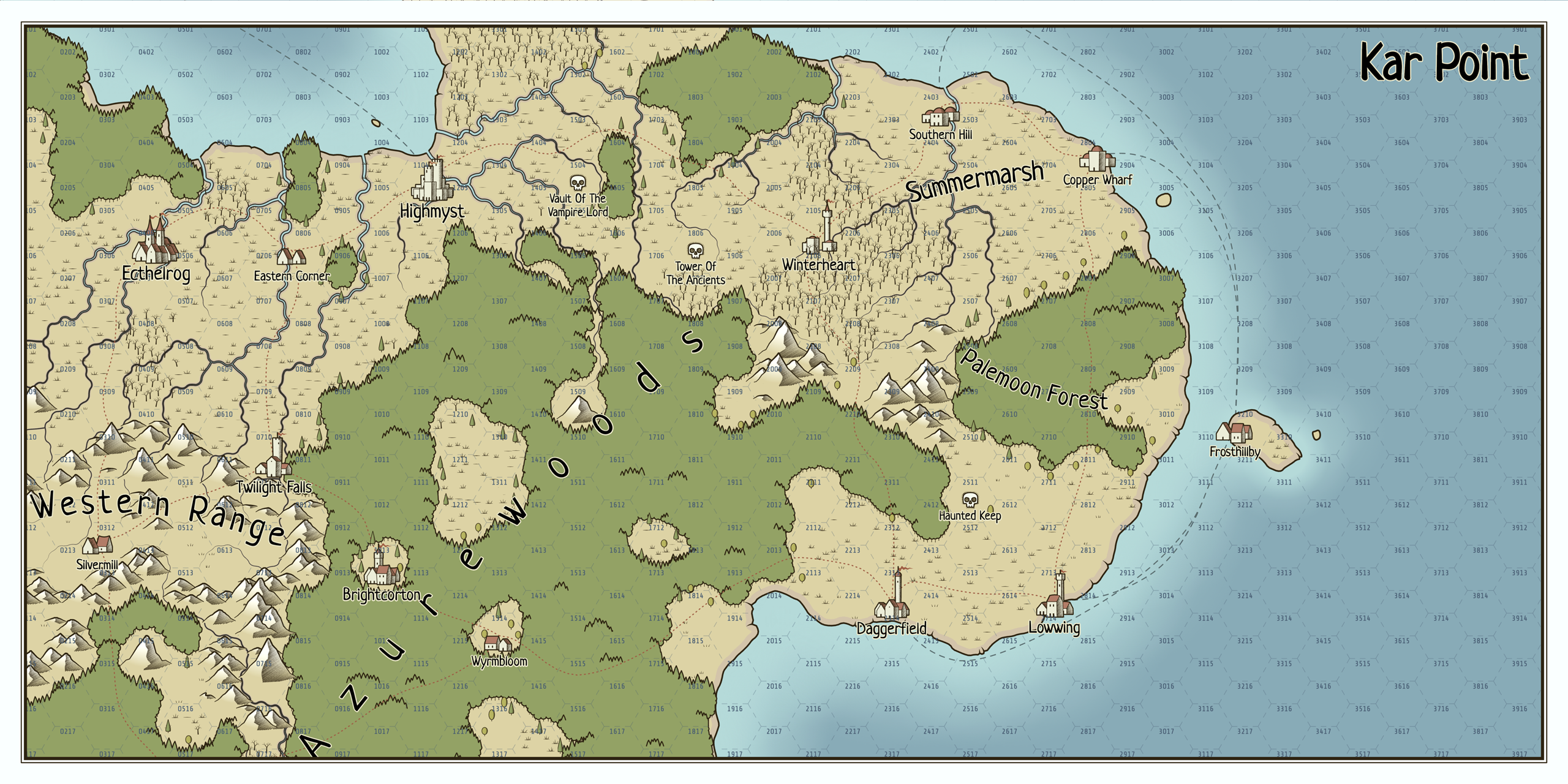
Perilous Shores
Right click to open the context menu with all the options. Press Enter to generate a new map; more shortcuts ⌨️here. Additional style presets are available 🎨here. For town icons in the style of this generator check Perilous Icons.
🃏This generator is a part of Procgen Arcana.
Made with Haxe + OpenFL.
You can use maps created by the generator as you like: copy, modify, include in your commercial rpg adventures etc. Attribution is appreciated, but not required. Please consider supporting this project on Patreon☕!
Development log
- 1.7.1: improved JSON export2 days ago
- 1.7.0: JSON export43 days ago
- 1.6.6: painterly optionsMar 27, 2025
- 1.6.5: fjords and curved labelsJul 30, 2024
- 1.6.4: improved islands and peninsulasMar 07, 2024
- 1.6.3: improved forestsFeb 07, 2024
- Collection of stylesDec 01, 2023
- 1.6.1: tributariesNov 28, 2023

Comments
Log in with itch.io to leave a comment.
how made this map?
Great ! Threw me for a loop when the default came up with tilted hexes (also had to hunt down my preset display settings I use- although the map viewer is agnostic as far as that goes).
Can we get a list of all the possible terrain types (what you use to populate Terrain="") field in the JSON ? I want to make an enum something similiar in case of future changes/additions ?
And now that you have water defined, maybe you can have water features (Bays, Seas etc) ? Haven't seen any generated yet so maybe they are there. Maybe even multiple of the map is large enough (e.g. a Bay off the coast that is in a Sea etc etc).
My travails with getting the UI to behave continue apace....
Excellent Work !
Not sure this is where to ask this stuff but here goes:
Can we get a comprehensive text list of the all your json terrain types ?
I noticed there is no terrain type open (just "") or water (just ""). Is it possible to fill in those with their appropriate types (e.g. "Ocean" and "Clear" when exporting ? Would make map AI easier to work with (suppose I could use a color check of the center of the hex to determine what it is but that gets messy)
It also seems to truncate the grid if there is empty (in this case water) to the right. Can it fully export all the hexes ? I suppose I could smart fill and assume its water but have to be careful not to include open terrain (again kind of messy when the data is already generated somewhere).
As if that is not enough :D, can we get as a future feature (pun intended) the features field to have a class associated with it (e.g. town, danger, wood_feature, mountain_feature etc etc ?) this would make it a breeze to generate some logic for quests, backstory etc etc.
Really love your Perilous Shores stuff. Its really got my creative juices flowing :D
Soon (tomorrow or maybe even today) a new version of the generator will be released, which will export maps a little differently.
Awesome ! I'm so close to getting a working model to tinker with once I can implement any changes when massaging the data into my data model.
Now that I think of it, I could just tie the feature back to the terrain type of one of its children hexes (unless its a danger or a town etc) as long as its consistent.
The next question will be what do I do with it when I get this whole thing running....
I really like all your applications! What software do you use to make these?
Most (all?) of them are made in Haxe + OpenFL.
Love the stuff here- really gets my creative juices going :D
I have a question though:
Is the hex grid using cube coordinates (and not offset) for its location ? I'm toying with the idea of making a fog overlay utility that I can use to reveal only hexes visible to a particular hex (it would reveal the current hex and a partial of any adjacent 6 hexes at a time).
Keep up the good work !
No, it's using "offset coordinates" for two reasons:
Cheers!
Wonderful ! Then it won't require me to wrap my old head around that.....
May be able to get something done on my android phone. I've got a good dungeon generator I've made in a similar style that allows crawling and I would like a good overland ability to do the same. If I can import the map and its JSON for data I can put a mask over the whole thing, pick a start spot and crawl, exposing the mask as I move along and when I hit a dungeon I can generate it in my program. Might be a little overly optimistic, but it may be worth a shot :D
BTW since you've already got most of the terrain stuff down, why not make a skirmish map generator in the same style ? These are the best set of easy to use tools around.....
What is a skirmish map? Is it the same as a battlemap? I personally don't use them, so I don't know what makes a good skirmish/battle map.
Yeah a simple battlemap- A road maybe, some trees, heights, maybe a field or two with a building etc etc. Can base it on the terrain in the overland hex possibilities. Bonus would be conforming it (more or less) to a hexgrid (like the overland). Very handy- I use a generator from another app I made to create these: https://drive.google.com/file/d/1Lc6kZZr6ZIr2l2mGmNu0jeq7z3NUOdmI/view?usp=drive... and https://drive.google.com/file/d/12GyIy8vO5Qu07BDD4c8_dRuFWl_7d-Ly/view?usp=drive...
Isn't this close enough (with the grid on)?
What size (in pixels) are the hexes you use and what is the line width (in pixels). I'm making it so that a click the map (im using the standard export PNG) can be converted into a hex coordinate ?
Internally the hex radius (the distance from its centre to any of its vertices) is 50 and the line widths (there are several types of them) are defined in the Style dialog. I don't think all this is very useful because in exported images different values are used depending on the map size.
Just wanted to share my appreciation for making these! I used your map generator to help prototype a top-down game idea.
Is this generator allowed to be used in video games? If so, can it be used commercially?
I'm not sure what being used in video games means, but:
I meant using a realm generated by the project, but thanks for the info.
I can’t say how excited I am for JSON exports. I’ve had to make map builders for my sideprojects from scratch and they always felt worse than your procgen arcana.
It would be great to have a way to undo or a way to see what changes will completely change the map. I really like the idea of this, but after loosing 30min work becasue I didn't know a setting would majorly change things (hex type) it feels like I'm juggling live grenades!
I'll probably move these options somewhere else so they don't look purely visual or non-destructive...
That would be great thank you!
Sorry for leaving a comment when I was frustrated.
You've saved me well over 30min, and I really appreciate your work.
👍
this is the best generator on the planet, hands down, can i put in a request for dungeon icons? if not that is way ok, this thing is the best, am disabled but as soon as i have some extra cash i am going to throw you some to donate towards your work
I'm not sure I understand your request :)
Hey, I love your work! Can you perhaps share the brushes you are using for trees and mountains (just like the cities and dangers in "perilous icons") please, so that I can modify the maps generated by Perilous Shores in GIMP? I would love to do some further customization and tweaking.
Thanks!
I'll consider this 👍
Is it possible to somehow export in layers, in order to have land apart from trees apart from towns apart from labels, etc.? This would help a lot in editing & adding details to the maps later in a drawing app.
It is not exactly exporting in layers, but if you export as SVG, you can (relatively) easily separate different types of objects within an export file.
Thanks!
I just love this generator. It's amazing to see it improve and improve. Thanks for sharing your wonderful work!
You can switch to the "scattered" mode by checking "Details > Individual trees" in the context menu or by pressing the i key. When individual trees are enabled, the "Tree density" and "Tree regularity" parameters in the Style dialog affect their look. Cheers!
Sorry I deleted the question on trees, I found out and wanted to save people time :)
Thanks for standing up!
I love the maps i already generated with this tool. I would like to develope a browser game using a map generated via this tool, but for it to work I need higher resolutions map, such as 16000x16000 pixels, is it possible? eventually i can generate them offline. Of course I will give you credits and support you via patreon. let me know. :)
It is not possible to export a map as a 256M bitmap image, but you can export it as SVG and convert to anything you need (and your tools allow).
I managed to export it as SVG, and modify it in illustrator and scaled it to 16000x16000. But doing so mountains and trees are 16 times bigger than they should be, so i should make a grid of 4x4 maps, but it is almost impossible to join them perfectly
I'm not sure I get what your goal is. I thought you just needed your "normal" map in high resolution (256K) and that's what you can achieve by exporting it as SVG, scaling up etc. Of course in this case individual objects become large (in pixels). If you need a map made of a large number of hexes, you can request one in the Region parameters dialogs by entering large numbers in the Size fields, but it can't be larger than 4000x4000 or something like that. And you can do both - generate a large map (4000x4000 for example) and scale it up. It is also possible to make a map look larger by using smaller values as Clutter scale and Town scale in the Style dialog.
How does one save the map?
You can either save a permalink to a map ("Permalink..." in the context menu) or export a map as SVG or PNG image ("Export as>" in the context menu).
Hello Watabou,
First of all, your tool is amazing 😍
I can't find the permalink option in the context menu, is it temporary disabled ?
the URL of the page does not contain the modifications I made on my map so I can't use that as a way of saving it for later edit ^^'
In any case keep up the good work and have a nice day 😁
Thank you!
The "Permalink..." item is the second from the bottom in the context menu. It works exactly the same as the link in the address bar of the Arcana version, i.e. it doesn't include modification made to a generated map. I am working on the JSON export feature and maybe it will become possible to import the files back making it possible to save and load (modified) maps normally.
Maybe I'm doing it wrong but I can only rarely get the settlement icons to delete. Is there a setting that will leave them off or a better way to delete them?
This is not the first report of problems with settlement deletion, but unfortunately I cannot reproduce this. If you don't need settlements at all, you can hide them instead of deleting: choose Details > Towns > Hidden in the context menu.
I have question I'm trying to import the map to roll 20 to use HEX grid but I cannot for the life of me get them to line up.
I'm not familiar enough roll20, sorry. I guess you checked that the hexes mode in the generator is set to "Pointy topped" or "Flat topped"?
Foundry VTT user here. I do not know about Roll20, but it must be similar.
I see 2 problems with importing generated map.
1. The hexes do not start "flush" at the edge. In Foundry, that means that I need to manually offset the map to fit the hex grid. This is a manual process; Foundry has a tool that helps quite a lot, but it's time consuming and imperfect. Ideally, the exported map from PS would have hexes starting flush at the edges. Here are the 2 ways "flat top" hexes cap be flush:
2. The "grid size" is not specified. In Foundry, maps are defined by how many pixels fit in a single grid square (the devs suggest at least 100 px, and that is what I use). For maps using a grid (like the ones generated by OPDG), it makes things super easy: export at 100 px, use the same size in Foundry and boom, everything lines up. In the best world, exporting a map from PS would be just as easy. Ideally, PS would scale their hexes to pixels per square so that exporting at say 100 px per square would fit easily and perfectly on a VTT. I read a reddit post where someone describe how to calculate it; maybe that could be useful to you: https://www.reddit.com/r/FoundryVTT/comments/t8anvc/hex_grids_in_foundry/
Thanks for taking the time to read and answer the comments! Also, thanks for everything you do :D
Thanks for the explanation!
Thank you for taking the time to read and answer!
Quick update about hex size: I just realized that Foundry consider that the hex size side to side is equal to the grid size. So 100 px per square is equal to 100 px per hex side to side.
Hope this helps!
Hey this is extremely cool and a very helpful tool. Will definitely consider supporting the project. Thank you!
I do have one question. Is it possible to update the icons on the map to different things? I saw a post showing some different icons earlier but can't find it and also I wasn't sure how I might import them to the tool
No, it's not possible. The generator doesn't use any pre-made assets (and can't import them), everything is drawn procedurally.
Are you asking about cities? All you can do is to choose between "pins" and actual icons (Details > Towns), change their size (via the Style dialog) and slightly change their look by rerolling internal parameters (Details > Towns > Random icons).
Is anyone else UNABLE to delete towns and dungeons, etc?
Could you describe what you do to delete a settlement (or a "danger") and what happens after that?
I am having the same issue. It works for a while and then just stops (have tried different browsers).
*EDIT: Solved this today. Sometimes you have to add the town to the almanac, then delete it. Works every time then.
Hello love this program was wondering if there was a way that it could work with an already pre existing map to help fill the areas?
Not at the moment, no. People sometimes ask about something like this, and I've considered the idea, but apparently everyone has quite different things in mind. A full-fledged editor might work for most cases, but that's definitely beyond the scope of this app.
Hi, I absolutely love your work! You are a hero! But I need help... I can't get any font to work. The font I'm requesting is installed on my PC. I type the name, but it just gets ignored. Do I need the parentheses, as visible in the default setup? I've tried this on a mac and a PC.
I'm sorry, I have no idea why this doesn't work for you... You definitely don't need parentheses. The font name should be entered exactly like it's spelled in whatever tool you're using, but the case doesn't matter. For example, "times NEW roman" will work, but "times new roman" (with the additional spaces) won't.
hey i dunno whats up but several of your generators are cutting off about 50-60 pixels, without touching the margin or overlay text. changing zooms and sizes doesn't affect it.
in regular it cuts it off on the right oops right and bottom. in full screen, it's the bottom edge which falls off. i cannot figure out if there's an element from itch or elsewhere doing it, but i don't think it's the ratings bar
huh. if we rotate, it then cuts off all the elements, margin and compass etc.
oh i see! it's every element, incl child elements. longer text gets its own margin cut off too.
I love this tool and have used it a lot in my solo roleplaying, but I'm surprised that a simple thing isn't in the parameters : the presence or absence of mountains. Every map has them, it's not toggable. Is it a choice or an oversight?
You can get a map with very few or no mountains by selecting the "lowland" tag.
Love the generator.
Question: Is there any way to change the type of terrain in a specific area? (ex: make a forest a desert)
Howdy, two suggestions/requests and a question! Firstly the question: it's about the town generator but it could be applied in general to any output, I made a map of town long ago and lost the permalink... is there any way to retrieve from the image I saved?
Suggestion nr.1 for 'Perilous shores': there is no chance to set grasslands as the main feature of a map; I recently looked for a countryside map with plain grasslands (for pastures) or cultivated fields... is there any chance to add this feature?
Suggestion nr.2 for 'Perilous shores': in a map, the only icons are towns/villages or dungeons (marked with the skull icon)... would it be possible to add other 'points of interest'? For instance: a ruin, a monastery, an architectural element like a column or an obelisk... or in general a pin point which is not 'dangerous' (i.e. an icon different than a skull)?
Thanks a lot in advance, best
I have a map with a layout that I like, but would like add some patchy trees in a large open grass lands. Is there the potential to allow placing of trees similar to how you can place dangers or towns? Im not talking about painting a whole map, just tweaking the terrain. Love the style, btw.
This is a more complex matter than it may seem. The placement of a single forest patch can affect neighboring terrains, not always in an obvious way. Maybe this will be implemented someday, but not anytime soon.
You are a genius. I cannot express how good/great this tool is. I will not stop making maps for everyplace you wonderful person.
Hi, I'm working on a generative RPG scenario tool that would create lore snippets/narrative arcs based on the users world database for my masters degree. Is there a chance of implementing your map generator in this project?
Well, if you figure out a way to do it without me giving you the source code, hosting the generator at your place or anything like that, then yes, why not :) But usually people resolve to pregenerating a large enough number of maps without invoking the generator afterwards (like here: https://hexroll.app/).
How can i print
Export as PNG or SVG and then print the image normally.
Hey! I've been using your generators for fun for quite a while, but recently I actually created and published a little thing, using Perilous Shores as a base: https://teorocco.itch.io/weaver-island
Thank you for making all these generators, they're incredible for inspiration and so much more :D
Cheers!
is it possible to save the map generated and open it back up exactly as it was similar to the other generators (town/village) would love to see this as a feature so i can then click through and generate the towns and villages from it as i go, currently each time i try and open the url i have saved it renames everything differently
just checked a similar post on your patreon, i think this is currently not possible :(
You are right, at the moment this is not possible.
Two "nits" that should be easy to fix: Avoid overlapping labels and use proper English title capitalization rules ("Zigurrat of the Raven Knight" not "Zigurrat Of The Raven Knight".)
Yeah, capitalisation is easy to fix. Overlapping labels are not.
Had to share... Definitely someone's vassal state.
Is this an easter egg for us or generator with an attitude lol
Not an easter egg, just a normal very English-sounding random name :)
Thank you for this amazing tool.
Are you planning on making an import/export JSON for the maps so we can edit a map with new stuff as needed?
I am considering this, but no work has yet begun. Cheers!
It's a great tool. Would love to know if there is an opportunity or offer the tool.
Is it possible to make two adjacent maps. So that they can seamlessly connect? That would solve some of the issues from the comments about map size.
Thank you very much for such a tool anyway.
People ask about this surprisingly often, but unfortunately I don't think it's possible within this particular generator.
This is utterly perfect for DCC, a game that is supposed to take place in a small region, where your characters have never been far from home and the hills at the edge of the village have a mystery over them. this is incredible and i use it often. thank you for sharing this with us.
Cheers!
Simple briliant, but ive got one problem...
For me, i need just a simple Europe map, but in a rockstar games way, fictional cities, lands, only based on Europe in basic shape. Is this possible to you? =)
Nope, currently there is no way to paint or upload land shapes.
This is cool, but personally feels too limited on size. Is there a way to make this big enough to be a full on continent? Settlements and the like feel too sparse and far apart, even with the civilized tag. Otherwise, really cool!
Calling these maps regional is my deliberate choice: I don't want to bother with different climate zones and similar things that need to be considered when generating maps of a continent scale. However, the scale is not specified here, so you can generate an island and treat it as a continent. The density of settlements is based on the fact that each map is made of hexes and I can't allow towns to be placed closer than 2-3 hexes from each other.
That makes sense! Thanks for the response, and the cool tool