thanks! this work is very usefull to play rpg with my wife.
a question... I try to compose the maps (to make a greater map), but it's very difficult to match the coastlines. could you create a representation of the mountains, cities, dunes, etc, seen only from above? that way I could rotate the maps and I would have a lot more variety. thank you very much!
Am I correct in thinking that the rivers cannot follow roads? I have a campaign with a town in it where a road through the town follows the river, and it looks like your generation algorithm can't ever produce this situation (at least, I tried a lot of times and never saw it happen). If it can't do this, it would be a cool feature, to add some extra verisimilitude I think - paths and roads often build up this way in real life.
They can’t do it really tightly because roads run through centres of hexes and rivers run along their edges.
They rarely do it for long. Roads connect settlements and they "try" to be as short as possible (where terrain allows). So for a road to follow a river for a noticeable length, two settlements need to be located at the same river and that river needs to run straight between them.
A road following a river is a nice image, but I don't think it happens much in real life. Essentially rivers make roads unnecessary, at least if we are speaking about roads for carts, caravans and stuff, not mere trails.
Your last point might be true (I have no way to verify either way, but I have seen a lot of paths and roads that follow a waterway for extended periods - I expect it was just easier to build a road on the flat near a lazy river, and they would then part ways at some point). However, in the case where a river makes building a road unnecessary, wouldn't you expect the river to connect up settlements?
2 - If you download the map (Export as PNG), the image will be at the maximum detail possible, so you can use your favorite image-viewer and zoom in and out to your likings.
I am not, sorry. It's harder than it probably seems. Filling gaps with water, mountains and woods is doable, but stuff like cities, roads and especially rivers makes it virtually impossible. Depending on the required level of seamlessness of course :)
None of my generators has the zoom feature for technical reasons which I hope will be resolved one day. If readability of labels is the only problem, you can use "stickers" - click any map feature to display its name and optional description.
4000 is the limit, sorry. This generator is not good at generating maps this big, it's not a "world generator". Also it gets too slow, especially when building landlocked regions.
Howdy, I am pretty new to the itch community and barely engaged, thus far, but I was just browsing about, just now, when I stumbled into your beautiful work here. Felt I just had to commend you on this gem you are crafting. Very fine work. Good day.
Nice tool you have here. I was considering use it to make maps of a world I'm building for my series of novels on Tapas. In some point it will get commercial (I hope). Is it okay for you (I may credit you in some way)?
Like uploading it back in the generator? No, it is not possible (although you can edit SVGs in Inkscape or Illustrator of course). Currently the only way to get back to a map is to save its permalink.
You're right. The mountains and forests are pretty darn close. What about fonts? I like Tolkien's style for labeling his maps. If one could change the type of font used, that would be awesome.
You can change fonts in the Style dialog (Style... > ... > Text). Any locally installed font can be used, but you need to type in its name manually (vs. choosing it from a list). Area labels (e.g. Mirkwood) will be added in the next update.
For me it's more convenient not to provide any real license and just say "I don't care (sort of)". There were cases when I did care and I know no license I am aware of would help me in those cases.
Hey I really love the progress you make with all your generators. As I encounter the same issue again and again I would like to ask, if there is an option that no settlements or other points of interest are on the edges of the map. I hace this so often...even the name isn't fully readable. Thank you in advance!!! :D
Could you give me an example (a permalink) with settlements too close to the map edges? This used to be a problem but I considered it fixed. Labels can be obscured by the map edges I guess, I'll look into it. Cheers!
Yeah, this is too close and I'll fix it. Please note, that since that frame is a purely visual element, it is not taken into account when map objects are placed.
You can use any font installed on your computer. All fonts from Google Fonts that I tried worked for me. Let me know if something doesn't work for you.
This is awesome. I'm using it to make DM and player's versions (less info but more stylish). Small sugestion, add an option to make the grid number more readable over objects.
There are some curuious perks. "Hexes orientation" changes object creation/distribution on the map (feature?). "Rugged" has the same effect, but only on "Pointy topped" hexes, not on flat or tilted.
EDIT: Playing with the url to retouch it without generating a completely new terrain. Is there an UX way to do refresh parameters without changing the seed?
You can try customizing hex numbers (Grid > Customize...) to improve readability.
Hex orientation affects the generation too much (e.g. the "same" island in different orientations may consist of different number of hexes), so it's impossible to build exactly the same map in a different orientation. It's neither a feature, nor a bug.
"Rugged" affecting anything apart from the coastline itself is a bug - I'll look into it.
Not sure I get what you are doing with the url. What parameters would you like to change without changing the seed?
I may be blind, but is there a way to save a map to come back to it later?
Also, I've noticed that when we click on a dungeon to open in 1PDG, the names get mixed up. For example, clicking on the Vault of Kylas on my map takes me to a map of the same name, but with a description that refers to it as "the Abbey of the LeperOracle."
To come back to a map you need to save its permalink. If you use the Arcana version of the generator, you can copy it right from the browser's address bar, otherwise, choose "Permalink..." in the context menu. As with my other generators, most manual changes made to a map are not saved in its permalink, but since there is not much to change in Perilous Shores, it's less of a problem here than in the city generator.
The thing with dungeon names is a known flaw of the integration of these two generators. When a dungeon is opened from Perilous Shores, a random dungeon with a random name is generated (but always the same for a given cell on a given map) and only the title of its map is changed to match the name in Perilous Shores. This will be fixed later.
Awesome. Thanks for the reply. These aren't major issues by any means. I was just curious about them and wasn't sure if the map naming was a known issue.
These generators are all fantastic and I appreciate having them available to use!
Press ~, 1, 2, 3 or 4 to select one of the preset style. The last one ("Cartoon") is the "least black and white" of them. Use the Style dialog ("Style..." in the context menu) to define a custom style.
can you not display the almanac anymore? I've tried everything and I'm stumped thx in advance, always a stellar job, but I'm curious as to why I can't find this feature
The almanac as a list of "important features" is still there, but since the legend has been removed, it can only be displayed as a set of stickers - ctrl+click (cmd+click on mac) any object on a map. Later all the features of the almanac will be marked with map labels.
thank you for the reply, I did confuse the Almanac and the legend; I rather liked the latter, but with the display issues it sometimes had, it's probably for the best
A feature I would really appreciate is to change the scale of hexes, make them bigger or smaller. Some of the regions I generate are really perfect for the game I want to run, but it's just too many hexes, which gets troublesome if you run with 6 mile hexes, the distances between towns and dungeon sites is a bit too far.
I'm not sure I get what the problem is. This generator produces maps without any assumptions about the size of individual hexes. If there are too many hexes per map, you can choose a smaller map size. If after converting hexes into miles you get too large distances, you can select a different conversion rate (e.g. 1 hex = 4 miles instead of 6). If a specific value of the hex size is important for you (for example, if you need it for calculating travel time or something like that) you can force the generator to spawn more settlements, effectively reducing the average distance between them. Or am I missing something?
There is no such option. It's probably not very hard to implement (although cells sharing a vertex but not an edge may produce odd results in some cases), but why would anyone need an overworld map made of squares?
Understandably this would be a lot to ask but imagine a more 'zoomed-out' generator with full compatability with your other generators, eg: A world generator where you can click on continents to get a perilous shores region generated in the shape of the continent/region.
Also perhaps you could add some non dangerous places of interest. I understand this is for roleplaying games such as dnd but I think it'd be neat to have some non dungeon and non village icons on the map, things like ruins, outposts, and temples don't all need to be dungeons and it would inspire a bit of lore making for the map. Especially if some icons were locations of old battles, holy sites, lone farms and the aforementioned ruins, outposts, and temples dont always need to be a skull on the map that loads a dungeon, they could also be a rumor icon with a short randomly generated description.
nonetheless I have ideas but none of the knowhow or perspective on how hard it is to make something like this so thank you for creating such an awesome tool.
I may want to make an abstract "world generator" in the future, but in this case I'll try to make it as independent of (while still integrated with) Perilous Shores as possible. I totally get the appeal of the idea of "super-generator of everything", but at the same time I am sure that generators with smaller scope are more useful in practice.
Regarding non-dangerous POIs: that's actually how I imagined them originally, but I couldn't come up with a decently looking icon for them. So they became skull-marked "dangers" with such way-to-easy-to-generate names as "Castle of Doom" and "Prison of The Mad Witch". It's probably too late to change them, but I am planning to embed some small pieces of generated lore into descriptions of geographical features (woods, mountains etc.).
Nope, sorry. I would recommend using the Arcana version of this generator (https://watabou.github.io/perilous-shores/). It's identical to the itch.io version, but it doesn't reset the map after refreshing the page (+ it's more convenient to use permalinks there).
This is super inspirational! The ability to toggle/add every region to the almanac with one click would be fantastic, but I don't see that as an option in this current version.
Thanks! Adding all the regions to the almanac would create a too long list, especially for a large map. Not only it looks bad (both as a legend, and a "sticker board"), but also highlights how imperfect are the generated names. As I wrote in the post about the latest update of PS, I am planning to get rid of the legend in favour of labels. Most likely this will affect the concept of almanac itself, so maybe "add everything to the almanac" feature will be implemented in some form after all.
I LOVE this project. Personally, I don’t like/am not inspired by other available hex tools. I want an evocative map with hexing lightly displayed. Great work!
Some thoughts:
yeah, kill the legend text; but the numbering is nice
needs a way to stitch multiple regions together… perhaps just a simple region prefix? Eg. 0101 could become A101? Like different regions can be the letter?
I WANT THAT SAVE FEATURE… but you’re on this
obviously, adding elements to the map… but I can also do this with a SVG editor… even an online one… maybe :D
I’m not always sure what each hex icon means. Would be great to post that somewhere. Eg. grasslands vs swamp, etc…
In theory, any map feature (a village, a forest, a mountain range etc.) can have a short text description which is displayed on it sticker. Currently there is no way to add or edit descriptions manually. Procedurally, descriptions are generated only for settlement. So in practice "Descriptions" only affect the text on a sticker when you click a village or a town. For example, it could be "Moonhill. An isolated fishing village notable for its lighthouse" if it's checked or just "Moonhill" otherwise. In the future, descriptions will be added to other types map entities and it will be possible to edit them.
Hi Watabou, nice work on the generator. Was playing around with it in Firefox and froze the browser 3 times in a row and required me to restart. Not sure if you have had that problem, but be great if you could fix it.
I played with the keyboard shortcuts and toggles. But I think it was because I generated a bunch of maps and I liked seeing how they encourage me to think about monster lairs.
Thanks! In theory you can download all the files of the generator and they should run offline normally (there is no server side) but I haven't tried it.
I've become a little obsessed with this. The only issue I've had is the legend is sometimes a little hard to read even using the outline text. Would it be possible to have a toggle for a background under the legend?
That's why I had thought it would need to be on a toggle, to avoid that problem. I suppose a transparency slider might allow a compromise between seeing map features and improving text contrast.
I really like your work, they are all just super. Did you have an idea to add the ability to add icons of cities and dungeons on the pre-generated map manually?
Maybe one day this will become possible but not anytime soon. Towns and (to a lesser degree) dungeons are not just placed randomly on map. They get verified not to be too close to each other, they get connected by roads (taking into account all the settlements at the same time) etc. For manually placed locations I would have to do the same and this seems kind of cumbersome...
Weird bug. When there are two or more dangers on a map and I right-click on them to be taken to 1PDG, they go to the same map with the same name (based on whichever one I clicked on first). If I get the permalink, reload the site in a fresh tab and out the permalink in, it apparently "remembers" which one I clicked first last time and keeps generating that dungeon map. But if I put the permalink into the address bar and go to the non-Itch version, I can then click on a different danger and get the map of that (but every subsequent click on a danger will then send me to that map). Oh, and features get renamed when the permalink is used to go between the Itch and non-Itch version. :-)
I just did some experimenting and it seems it might be to do with Chromium? The issue disappears when I use Safari but exists when I use Chrome or Edge.
← Return to generator
Comments
Log in with itch.io to leave a comment.
thanks! this work is very usefull to play rpg with my wife.
a question... I try to compose the maps (to make a greater map), but it's very difficult to match the coastlines. could you create a representation of the mountains, cities, dunes, etc, seen only from above? that way I could rotate the maps and I would have a lot more variety. thank you very much!
Or an option to rotate the generated map!
Thank you so much for this wonderful tool!
Oh and one more thing... can it generate plateaus?
Not explicitly, no. Do you have an example how plateaus would look look on a map of this style/scale?
I have one question/suggestion...
Am I correct in thinking that the rivers cannot follow roads? I have a campaign with a town in it where a road through the town follows the river, and it looks like your generation algorithm can't ever produce this situation (at least, I tried a lot of times and never saw it happen). If it can't do this, it would be a cool feature, to add some extra verisimilitude I think - paths and roads often build up this way in real life.
It’s no like they cannot at all but…
Your last point might be true (I have no way to verify either way, but I have seen a lot of paths and roads that follow a waterway for extended periods - I expect it was just easier to build a road on the flat near a lazy river, and they would then part ways at some point). However, in the case where a river makes building a road unnecessary, wouldn't you expect the river to connect up settlements?
This tool is stunning.
You are doing a wonderful job! Congratulations !!!!!!
1 - Are you planning any updates where it's possible to connect maps in an organic way?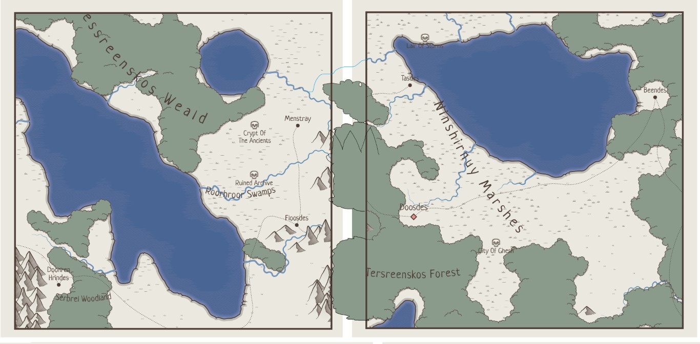
Sorry for the exemple XD.
2 - While using Perilous I missed a zoom. On larger maps it is difficult to read the subtitles without some kind of zoom.
2 - If you download the map (Export as PNG), the image will be at the maximum detail possible, so you can use your favorite image-viewer and zoom in and out to your likings.
I'm using it this way. :D
Thank you!
Cool stuff as always. :D
Just lovely to flick through maps and see them. =)
Hi there. This generator is absolutely amazing! I'm trying my hand at OSR solo play, and find this to be very helpful!
Question. Is the upper map size limit 4000x4000? By chance, is there any way to generate a much larger map? :)
Thank you!
4000 is the limit, sorry. This generator is not good at generating maps this big, it's not a "world generator". Also it gets too slow, especially when building landlocked regions.
Howdy, I am pretty new to the itch community and barely engaged, thus far, but I was just browsing about, just now, when I stumbled into your beautiful work here. Felt I just had to commend you on this gem you are crafting. Very fine work. Good day.
Thank you!
Hi, there!
Nice tool you have here. I was considering use it to make maps of a world I'm building for my series of novels on Tapas. In some point it will get commercial (I hope). Is it okay for you (I may credit you in some way)?
Hi! Sure,and as it's said in the description, "attribution is appreciated, but not required".
Anyway of uploading SVG you worked on and saved so you can add more to it or change it?
Like uploading it back in the generator? No, it is not possible (although you can edit SVGs in Inkscape or Illustrator of course). Currently the only way to get back to a map is to save its permalink.
This is such a cool generator. Have you thought about using Tolkien style trees, mountains, rivers, etc.
Thanks! Adjusting different style settings can get you close enough to Tolkien's style, unless you need something very specific.
You're right. The mountains and forests are pretty darn close. What about fonts? I like Tolkien's style for labeling his maps. If one could change the type of font used, that would be awesome.
You can change fonts in the Style dialog (Style... > ... > Text). Any locally installed font can be used, but you need to type in its name manually (vs. choosing it from a list). Area labels (e.g. Mirkwood) will be added in the next update.
Ok I see that now. Thanks for clarifying. What an awesome feature. Can you change font color too?
Currently it is not possible, but probably I will add a separate color for the labels in the future.
This generator is wonderful, really love it
There is a way to add new sites into the map?
No.
Maybe it could be a nice feature, to add manually at some point on the map a new site.
This tool’s fantastic, and I like the little variations on some of the icons.
I’ve exported a few to Inkscape.
If it’s all free, why not stick it under the GPL?
Thanks!
For me it's more convenient not to provide any real license and just say "I don't care (sort of)". There were cases when I did care and I know no license I am aware of would help me in those cases.
Well, thanks for making it free. I have an open source TTRPG, so I’ll see if I can use the generated maps.
Hey I really love the progress you make with all your generators. As I encounter the same issue again and again I would like to ask, if there is an option that no settlements or other points of interest are on the edges of the map. I hace this so often...even the name isn't fully readable. Thank you in advance!!! :D
Could you give me an example (a permalink) with settlements too close to the map edges? This used to be a problem but I considered it fixed. Labels can be obscured by the map edges I guess, I'll look into it. Cheers!
hey, if it helps, I have an example here
https://watabou.github.io/perilous-shores/?seed=1514430085&tags=peninsula,highland,civilized,barren,neutral
Thanks!
Yeah, this is too close and I'll fix it. Please note, that since that frame is a purely visual element, it is not taken into account when map objects are placed.
Thank you for posting...sorry I was so bussi :D
Love the generator, do you have a list of compatible Fonts?
You can use any font installed on your computer. All fonts from Google Fonts that I tried worked for me. Let me know if something doesn't work for you.
This is awesome. I'm using it to make DM and player's versions (less info but more stylish). Small sugestion, add an option to make the grid number more readable over objects.
There are some curuious perks. "Hexes orientation" changes object creation/distribution on the map (feature?). "Rugged" has the same effect, but only on "Pointy topped" hexes, not on flat or tilted.
EDIT: Playing with the url to retouch it without generating a completely new terrain. Is there an UX way to do refresh parameters without changing the seed?
I may be blind, but is there a way to save a map to come back to it later?
Also, I've noticed that when we click on a dungeon to open in 1PDG, the names get mixed up. For example, clicking on the Vault of Kylas on my map takes me to a map of the same name, but with a description that refers to it as "the Abbey of the LeperOracle."
To come back to a map you need to save its permalink. If you use the Arcana version of the generator, you can copy it right from the browser's address bar, otherwise, choose "Permalink..." in the context menu. As with my other generators, most manual changes made to a map are not saved in its permalink, but since there is not much to change in Perilous Shores, it's less of a problem here than in the city generator.
The thing with dungeon names is a known flaw of the integration of these two generators. When a dungeon is opened from Perilous Shores, a random dungeon with a random name is generated (but always the same for a given cell on a given map) and only the title of its map is changed to match the name in Perilous Shores. This will be fixed later.
Awesome. Thanks for the reply. These aren't major issues by any means. I was just curious about them and wasn't sure if the map naming was a known issue.
These generators are all fantastic and I appreciate having them available to use!
Im sorry if I sound dumb but is there a way to change the map so its not black and white?
Press ~, 1, 2, 3 or 4 to select one of the preset style. The last one ("Cartoon") is the "least black and white" of them. Use the Style dialog ("Style..." in the context menu) to define a custom style.
It seems like when I export to PNG, the outline of the text labels vanishes
Yeah, it was the same with the legend. Hopefully I will find a way to fix it. For now you can try exporting as SVG.
can you not display the almanac anymore? I've tried everything and I'm stumped
thx in advance, always a stellar job, but I'm curious as to why I can't find this feature
The almanac as a list of "important features" is still there, but since the legend has been removed, it can only be displayed as a set of stickers - ctrl+click (cmd+click on mac) any object on a map. Later all the features of the almanac will be marked with map labels.
thank you for the reply, I did confuse the Almanac and the legend; I rather liked the latter, but with the display issues it sometimes had, it's probably for the best
in any case, your work is fantastic!
A feature I would really appreciate is to change the scale of hexes, make them bigger or smaller. Some of the regions I generate are really perfect for the game I want to run, but it's just too many hexes, which gets troublesome if you run with 6 mile hexes, the distances between towns and dungeon sites is a bit too far.
I'm not sure I get what the problem is. This generator produces maps without any assumptions about the size of individual hexes. If there are too many hexes per map, you can choose a smaller map size. If after converting hexes into miles you get too large distances, you can select a different conversion rate (e.g. 1 hex = 4 miles instead of 6). If a specific value of the hex size is important for you (for example, if you need it for calculating travel time or something like that) you can force the generator to spawn more settlements, effectively reducing the average distance between them. Or am I missing something?
Is there an option for square grid instead of hex? If not, I'd like to suggest that it would be usefull
There is no such option. It's probably not very hard to implement (although cells sharing a vertex but not an edge may produce odd results in some cases), but why would anyone need an overworld map made of squares?
Understandably this would be a lot to ask but imagine a more 'zoomed-out' generator with full compatability with your other generators, eg: A world generator where you can click on continents to get a perilous shores region generated in the shape of the continent/region.
Also perhaps you could add some non dangerous places of interest. I understand this is for roleplaying games such as dnd but I think it'd be neat to have some non dungeon and non village icons on the map, things like ruins, outposts, and temples don't all need to be dungeons and it would inspire a bit of lore making for the map. Especially if some icons were locations of old battles, holy sites, lone farms and the aforementioned ruins, outposts, and temples dont always need to be a skull on the map that loads a dungeon, they could also be a rumor icon with a short randomly generated description.
nonetheless I have ideas but none of the knowhow or perspective on how hard it is to make something like this so thank you for creating such an awesome tool.
I may want to make an abstract "world generator" in the future, but in this case I'll try to make it as independent of (while still integrated with) Perilous Shores as possible. I totally get the appeal of the idea of "super-generator of everything", but at the same time I am sure that generators with smaller scope are more useful in practice.
Regarding non-dangerous POIs: that's actually how I imagined them originally, but I couldn't come up with a decently looking icon for them. So they became skull-marked "dangers" with such way-to-easy-to-generate names as "Castle of Doom" and "Prison of The Mad Witch". It's probably too late to change them, but I am planning to embed some small pieces of generated lore into descriptions of geographical features (woods, mountains etc.).
What Fonts are there to use? I thought google fonts, but I cannot use Grenze Gotisch.
You can use any font installed on your computer. So if you want to use Grenze Gotisch, first you need to download and install it locally.
is there a way to recover a map you accidently refreshe
Nope, sorry. I would recommend using the Arcana version of this generator (https://watabou.github.io/perilous-shores/). It's identical to the itch.io version, but it doesn't reset the map after refreshing the page (+ it's more convenient to use permalinks there).
This is super inspirational! The ability to toggle/add every region to the almanac with one click would be fantastic, but I don't see that as an option in this current version.
Thanks! Adding all the regions to the almanac would create a too long list, especially for a large map. Not only it looks bad (both as a legend, and a "sticker board"), but also highlights how imperfect are the generated names. As I wrote in the post about the latest update of PS, I am planning to get rid of the legend in favour of labels. Most likely this will affect the concept of almanac itself, so maybe "add everything to the almanac" feature will be implemented in some form after all.
Oh, wow! Sorry I missed that post; I appreciate the response. I look forward to your updated works. Keep it up! :)
Love this, but sadly the save pregen link feature isn't working for me on large maps here or off itch.io. Small thing...but MAN is this great
Apparently permalinks are broken for any sizes other than the default (medium) one. This will be fixed asap. Thanks for the report!
I love coming here and messing around with all the generators! Did the ability to change mountain types move? I cannot seem to find it.
Thanks in advance and really fun work.
Are you talking about "jagged" mountains? This is a style option: Style > Terrain > Jagged.
Thank you
I LOVE this project. Personally, I don’t like/am not inspired by other available hex tools. I want an evocative map with hexing lightly displayed. Great work!
Some thoughts:
0101could becomeA101? Like different regions can be the letter?Fantastic work, sir… bravo!
Excellent product here, Watabou! I had a question. What are "descriptions?" I don't see any and I don't know what that menu option does. Thanks
In theory, any map feature (a village, a forest, a mountain range etc.) can have a short text description which is displayed on it sticker. Currently there is no way to add or edit descriptions manually. Procedurally, descriptions are generated only for settlement. So in practice "Descriptions" only affect the text on a sticker when you click a village or a town. For example, it could be "Moonhill. An isolated fishing village notable for its lighthouse" if it's checked or just "Moonhill" otherwise. In the future, descriptions will be added to other types map entities and it will be possible to edit them.
A bit more info here: https://www.patreon.com/posts/perilous-shores-61720163
Hi Watabou, nice work on the generator. Was playing around with it in Firefox and froze the browser 3 times in a row and required me to restart. Not sure if you have had that problem, but be great if you could fix it.
BTW - I think your project is cool!
I haven't received reports on this issue before. Did it happen with some specific settings like tags or map dimensions?
I played with the keyboard shortcuts and toggles. But I think it was because I generated a bunch of maps and I liked seeing how they encourage me to think about monster lairs.
"Upwellcote: A busy logging village notable for the unique kind of duck puddings made only here."
My hat goes off to you, friend. Love this! Drawn straight into the world with this delightful little bit of color text.
Thanks! I'm planning to replace these descriptions with something more exciting and (more importantly) less repetitive :)
I guess the nature of these projects, is that you can add more depth, more variety, more interconnectedness, more everything, forever! :D
I'm working on a game called Secret Keep, which is fairly early in development, creative procgen archipelagos, with mission based gameplay.
It's always inspiring to see what you are doing with your generators, for little ideas and inspiration. :D Soooo muuuuch tooo dooooo!
Here's a little Dev Diary Video from a while ago, if you're interested to see where I'm at with it. :D
Keep making the magic!Nice! Good luck with your game!
Great work! The result is amazing!
Is it possible to run this offline?
Thanks! In theory you can download all the files of the generator and they should run offline normally (there is no server side) but I haven't tried it.
Wow, this looks great also for DND GMs I think.
I've become a little obsessed with this. The only issue I've had is the legend is sometimes a little hard to read even using the outline text. Would it be possible to have a toggle for a background under the legend?
I'll consider it. Also this: https://itch.io/post/5728531.
The problem is that the legend is likely to overlap at least some map features and its background would block them completely.
That's why I had thought it would need to be on a toggle, to avoid that problem. I suppose a transparency slider might allow a compromise between seeing map features and improving text contrast.
Thanks!
Maybe one day this will become possible but not anytime soon. Towns and (to a lesser degree) dungeons are not just placed randomly on map. They get verified not to be too close to each other, they get connected by roads (taking into account all the settlements at the same time) etc. For manually placed locations I would have to do the same and this seems kind of cumbersome...
Weird bug. When there are two or more dangers on a map and I right-click on them to be taken to 1PDG, they go to the same map with the same name (based on whichever one I clicked on first). If I get the permalink, reload the site in a fresh tab and out the permalink in, it apparently "remembers" which one I clicked first last time and keeps generating that dungeon map. But if I put the permalink into the address bar and go to the non-Itch version, I can then click on a different danger and get the map of that (but every subsequent click on a danger will then send me to that map). Oh, and features get renamed when the permalink is used to go between the Itch and non-Itch version. :-)
I did a screen-record:
I just did some experimenting and it seems it might be to do with Chromium? The issue disappears when I use Safari but exists when I use Chrome or Edge.
I'll check it. Thanks for the report!
It should be fixed now.